 TemperateReefBase Geonetwork Catalogue
ENVIRONMENTAL ASSESSMENTS
Type of resources
Topics
Keywords
Contact for the resource
Provided by
Years
-
The Davis Aerodrome Project (DAP) collected a range of environmental survey data over several field seasons to support a comprehensive environmental assessment of the proposed aerodrome. This data includes flora, fauna, soils, lake ecosystem, nearshore, marine, air quality and meteorological information which has been collected by a number of different methods, and extends across the current Davis Station, proposed aerodrome and supporting infrastructure footprint (Ridge Site), previous sites considered for the aerodrome (Heidemann Valley, Adams Flat), as well as locations across the Vestfold Hills away from any of the proposed developments. This dataset contains long-term underwater acoustic recordings made for the Australian Antarctic Division’s Davis Aerodrome Project 5097 environmental assessments. Calibrated measurements of sound pressure were made at two sites in the vicinity of Davis Research station (approx. 5km west of the station and one in Long Fjord to the north of station). The attached data was downloaded from the instrument deployed west of Davis Station. Data was recorded over 7 months using a custom moored Autonomous Multichannel Acoustic Recorder (AMAR G4) designed and manufactured by JASCO Applied Science following specifications provided by the Australian Antarctic Division. These moored acoustic recorders were designed to operate for year-long, near shore, Antarctic deployments. The moorings were deployed through the ice during the 2021 winter and one retrieved during the 2021/22 summer when the seaice was clear of the surface. The Autonomous Multichannel Acoustic Recorder is a fully autonomous underwater sound and data recorder. The acoustic recorder included a factory calibrated M36-100 hydrophone, data acquisition electronics and solid state digital storage (SDHC) to reduce power consumption and mechanical self-noise (e.g. from hard-drives with motors and rotating disks). Batteries, SDHC cards and electronics were placed in watertight pressure sealed PVC housing rated to a depth of 250 m. The moorings were secured to the seafloor by weights and suspended up into the water column by a string of floats attached to the top of the structure to separate the recorder and hydrophone from sea-bed. The hydrophone was securely mounted to the base of the AMAR housing. All connections between mooring components where taped with protective coverings to reduce mechanical self-noise from movement of the structure. The target noise floor of each recorder was below that expected for a quiet ocean at sea state zero. The data for each recording site comprise folders of 24-bit WAV audio files recorded on a duty cycle with two different sample rates. The duty cycle recorded for 60 s at a sample-rate of 512 kHz, followed immediately by a 580 s at a sample-rate of 32 kHz, and then 280 s off before repeating. The names of each WAV file correspond to instrument serial number followed by the start time (in UTC) of the file as determined by the AMAR’s real-time clock e.g. AMAR897.20210722T061621Z.wav would correspond to a wav from AMAR serial number 897 that starts at 06:16:21 on 22 July 2021 (UTC).
-
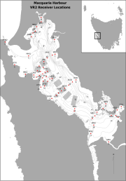
Fixed position oxygen and water temperature logger data from the Macquarie Harbour World Heritage Area (WHA). Two Hobo oxygen data loggers are positioned at approximately 15 m depth at different sites within the WHA, with the intent of monitoring representative mid-bottom water oxygen values in the WHA as these were identified in previous studies to be naturally low due to limited seawater exchange at the harbour entrance, and thus likely to be most susceptible to anthropogenic factors that may increase oxygen demand and alter WHA conservation values. These values include core habitat of the Maugean Skate, a listed threatened species. This work is funded by WHA advisory board via the Nature Conservation Branch of DPIPWE and is part of a larger study being conducted by IMAS undertaking a biological baseline study of the biodiversity of the Macquarie Harbour WHA. This data spans 08/11/14 to present (most recent update 02/02/17).